Environment, climate change and health

Environment, climate change and health

TDR/ A.Craggs
© Credits

Overview

The TDR/IDRC Research Initiative on VBDs and Climate (Population health vulnerabilities to vector-borne diseases: Increasing resilience under climate change conditions in Africa; Ramirez B et al., 2017), was focused on the particular health threat posed by VBDs in the broader development context of human vulnerability to climate change.

Project 1. Social, environmental and climate change impact of VBDs in arid areas in Southern Africa (malaria and schistosomiasis in Botswana, South Africa and Zimbabwe); College of Health Sciences, University of Kwazulu-Natal, Durban, South Africa

Project 2. Early warning systems for improved human health and resilience to climate sensitive vector-borne diseases in Kenya (malaria and Rift Valley Fever in Kenya); Oginga Odinga University of Science and Technology, Bondo, Kenya

Project 3. Predicting vulnerability and improving resilience of the Maasai communities to vector-borne infections (African trypanosomiasis in Tanzania); Nelson Mandela African Institute of Science and Technology, Arusha, Tanzania

Project 4. Alleviating the effects of climate change through understanding the human-vector-parasite interactions (African trypanosomiasis in Tanzania and Zimbabwe); South African Centre of Excellence in Epidemiological Modelling and Analysis, University of Stellenbosch, South Africa

Project 5. Vulnerability and resilience to vector borne diseases in northern and southern fringes of the Sahelian Belt in the context of climate change (malaria and schistosomiasis in Cote d’Ivoire and Mauritania); Centre Suisse de Recherches Scientifiques en Cote d’Ivoire, Abidjan, Cote d’Ivoire

In collaboration with: IDRC Canada, International Research Institute for Climate and Society, WHO PHE, WHO AFRO PHE, WMO


Achievements

New knowledge and evidence on the impacts of changing VBD risks, environmental exposure and social vulnerabilities under climate change and associated health outcomes. These are assessed and characterized under various environmental, social and climatic conditions in Africa. New knowledge and evidence generated from the projects are detailed in scientific papers that have been published. Additional information can be Achievements obtained from the online knowledge-sharing platform.

Decision-making and support processes and tools for VBDs and adaptation to climate change interventions have been developed, for example, VBD and climate change adaptation interventions: Tools to enable access to and use of climate services for health were developed (Ceccato P et al., 2018, and Thomson M et al., 2018).

For the research initiative, several methodologies using remote sensing to monitor climate variability, environmental conditions, and their impacts on the dynamics of VBDs were developed. The research initiative demonstrated how remotely-sensed data can be accessed and analyzed, and how they can be integrated into research and decision-making processes for mapping risks, creating early warning systems (EWSs), and evaluating the impacts of disease-control measures.

This research initiative recognized that one of the most pressing needs for operational health agencies is the strengthening of current disease control efforts to bring down disease rates and manage short-term climate change risks. This may, in turn, increase resilience to long-term climate change.

To address this need, TDR collaborated with the International Research Institute for Climate and Society (IRI) at Columbia University to develop research tools and networks. Researchers, policy- and decision-makers, public health practitioners, and communities from lower- and middle-income disease-endemic African countries received capacity building and access to and use of climate services for health. The following is a brief list of some of the learning and capacity-building activities:

  • Understanding and establishing the relationship between diseases and climate by creating spatial and temporal stratification of the diseases and population risk (i.e. risk mapping);
  • Estimating the seasonality of the disease and timing of intervention; and

Developing and implementing frameworks for EWSs for real-time monitoring real-time and forecasting the risks of disease transmission based on climate and environmental factors.

When working with VBDs, researchers and decision-makers often face a lack of quality climate data required for optimal targeting of the intervention and surveillance. While raw climate data (station- and satellite-generated) can be accessed freely online, this is not always readily available, especially in Africa; and whenever data is available, processing the data appropriately requires technical skills. Thus, ease of access should not be mistaken for ease of analysis since the datasets are highly complex and require complex analysis, especially when applied to decision-making. Various core tools have been developed to improve data accessibility and analysis for use by decision-makers and researchers across all projects supported under this research initiative.

Networks can support the development and use of decision-making and support systems for better management of VBD risks and vulnerabilities related to climate change in Africa. This networking engages cadres of young researchers from African countries and aims to increase skills development to identify appropriate research topics, and obtain, manage and use social, environmental and climate information in VBD research (see Annex 5 for a list of research published).

A Climate Data Library as an integrated knowledge system, organized as a library, and containing a collection of both locally held and remotely held datasets for earth observations.  

Smartphone applications were developed for:

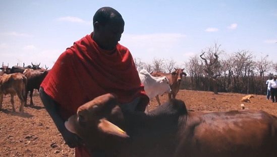
  • Integrating satellite images on precipitation, temperature and water bodies with local data on habitats of tsetse flies and occurrence of cattle trypanosomiasis. This application allowed the Maasai community and local officials to access high-spatial resolution images and extract time-series analysis for mapping the risks of trypanosomiasis in the Maasai villages; and
  • Collecting health data geo-referenced with pictures of the environment, data of vector breeding sites, data from socioeconomic and health surveys. This application is based on Open Data Kit (ODK)[1] and can create decision support for researchers, communities and public health practitioners to build multimedia-rich customized mapping tools.

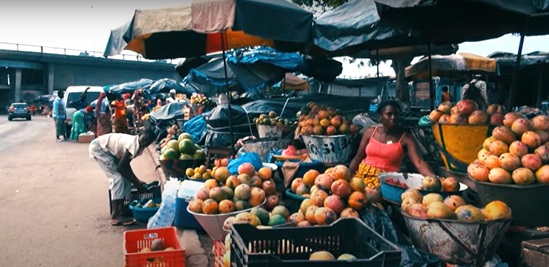
Online Course for Gender-Based Analysis in Climate Change and Vector-Borne Disease Research. Developed in collaboration with The Department of Social and Behavioural Sciences at the University of Ghana (led by Dr Phyllis Dako-Gyeke), this course adopts innovative global classroom approaches to provide a holistic and detailed understanding of gender-related roles and practices between men and women and its impact on climate change and vector-borne diseases, and vice versa. The course begins with an introduction to the definition of gender, gender terms and concepts, as distinct from biological differences between males and females. Participants will also be introduced to the various social, economic and health impacts of climate change and VBDs, and appropriate strategies for mitigation. Furthermore, the course introduces participants to various gender analysis frameworks and demonstrates how these frameworks could be applied to the domain of VBDs, climate change and public health programming.

[1] The Open Data Kit community produces free and open-source software for collecting, managing, and using data in resource-constrained environments. It allows the collection of data offline and submit the data, when internet connectivity is available.


Other tools developed for disease-specific applications

Malaria

Use of ecological mapping of Anopheles arabiensis larval habitats for larval control programmes has been a focus of tool development. Indicators like floods and diversified breeding sites and their contribution to prolonged and prolific larval breeding, “short” aquatic vegetation, turbidity and water conductivity were useful as early warning indices for predicting larval numbers. The following are other tools related to malaria:

  • Malaria outbreak prediction tools, based on data interactions between climate variables and malaria, are used for predicting outbreaks and for the design of preparedness interventions. This includes the analysis and use of clinical malaria transmission patterns and its temporal relationship with climate (rainfall, flood discharge and extent, mean minimum and mean average temperatures) which is then correlated with the incidence of clinical malaria cases.
  • The vector dynamics tool is used to inform more effective strategies for IRS in malaria elimination programmes, using essential and relevant entomological indices that contribute to malaria transmission of the indoor-resting population of Anopheles arabiensis
  • Disability-adjusted life year (DALY) metrics are used to assess the burden of malaria and provide a better understanding of the impact of malaria in communities. It is important to estimate the malaria burden to assist policy-makers in formulating evidence-based decisions when planning resources for malaria control and prevention.
  • Mapping the spatial distribution of malaria incidence was useful in improving the planning and implementation of malaria elimination programmes.
  • A tool to monitor malaria trends and the association with climate variables in Zimbabwe determined that the period of high malaria risk is associated with precipitation and temperature at 1–4 months prior to the seasonal cycle. Intensifying malaria control efforts over this period will likely contribute to lowering the seasonal malaria incidence.
  • A time-series analysis tool was used for exploring the relationship between climate variables, based on data gathered by the IRI and the Lamont-Doherty Earth Observatory (LDEO) climate databases to track and analyse malaria transmission dynamics and develop effective malaria control strategies.
  • A malaria hotspots mapping tool for tracking changing climate conditions was useful in mounting focused interventions within Baringo county, Kenya and included integrated mosquito control and chemotherapy for infected individuals.
  • A malaria risk mapping tool, which incorporates the seasonal and year-to-year correlations (period covered 2004–2015) between climatic factors (rainfall and temperature) and vegetation cover and related implications for malaria risks in Baringo county, Kenya was useful for planning malaria control.
  • A modelling tool to investigate the relationship between climate and environmental conditions and Anopheles gambiae s.l. larvae abundance was useful in zone-specific malaria interventions, such as the one focused on a dry season vector control strategy in the riverine zone.
  • A framework for malaria control for communities in Baringo county, Kenya based on trends and local knowledge of malaria, was used to minimize the impacts and enhance uptake of appropriate malaria management mechanisms.

Schistosomiasis

  • The Maximum Entropy (Maxent) modelling tool was used for the analysis of spatial and seasonal distribution of suitable habitats for Bulinus globosus and Biomphalaria pfeifferi snail species (intermediate hosts for Schistosoma haematobium and S mansoni, respectively). It was determined as a robust model for determining snail habitat suitability and is also useful in informing the development of vector control and management strategy for schistosomiasis.
  • A community-based malaria early warning system model was developed using community indigenous knowledge systems (IKS) indicators (insects, plant phenology, animals, weather and cosmological characteristics).
  • Participatory methodological tools were used to capture local knowledge of communities for memories of experiential impacts of and adaptation to key environmental and anthropogenic change events; differentiated memories of historical events by communities are complementary and necessary in developing a comprehensive adaptation strategy.

Rift Valley fever virus (RVFV)

  • Vector presence modelling may be useful in predicting the distribution of RVF vector species under climate change scenarios to demonstrate the potential for geographic spread of RVFV and to develop a risk map for spatial prediction of RVFV outbreaks.

Trypanosomiasis

  • A mapping and analysis tool showed that trypanosome prevalence is dependent on fly availability, and temperature drives both tsetse fly relative abundance and trypanosome prevalence. This tool is useful for designing community-wide vector and disease control interventions and planning sustainable regimes for the reduction of the burden of trypanosomiasis- endemic pastoral areas, such as the Maasai Steppe in northern Tanzania.
  • A mathematical model was used to track the transmission of Trypanosoma brucei rhodesiense by tsetse vectors to a multi-host population through the application of insecticides to cattle, either over the whole body or to restricted areas of the body, known to be favoured tsetse feeding sites. The restricted application technique resulted in improved cost-effectiveness, providing a cheap, safe, environment-friendly and farmer-based strategy for the control of vectors and Trypanosoma brucei rhodesiense in humans.
  • Insecticide-treated screens, called targets, that simulate hosts can be one of the most economical and effective methods of tsetse control.
  • Mapping tools provide substantial potential benefits to bovine trypanosomiasis control and facilitate more effective cost analysis of different approaches. Five intervention approaches are trypanocides, targets, insecticide-treated cattle, aerial spraying and the release of sterile males. Mapping the specific benefits of each approach helps decision-makers and planners to define strategies, assists in prioritizing areas for intervention, and helps identify the most appropriate intervention approach.
  • Geostatistical models predict local-scale spatial variation in the abundance of tsetse vectors of human and animal African trypanosomes, which allow vector control managers to identify sites predicted to have relatively high tsetse abundance, and to design and implement improved surveillance strategies.

Capacity and network building in Africa

Community of practice (CoP) established:

  • A web-based knowledge-sharing platform, VBD-environment.org, was launched in July 2015 and continues to be supported. At least 100 young researchers and public health practitioners from African countries are part of this network.
  • The CoP promotes participation in and/or organization of several capacity-building workshops and scientific fora.
  • The network is also involved in advancing academic degrees for 59 students (MSc, PhD and postdoctoral programmes).
  • Through the CoP, communities and relevant stakeholders and partners actively contributed to the research process and participated in capacity-building activities.